您好,登錄后才能下訂單哦!
您好,登錄后才能下訂單哦!
這篇文章主要介紹了Vue使用高德地圖如何搭建實時公交應用功能,具有一定借鑒價值,感興趣的朋友可以參考下,希望大家閱讀完這篇文章之后大有收獲,下面讓小編帶著大家一起了解一下。
最近項目要使用高德地圖寫了一個實時公交的應用,這邊分享一個小應用主要熟悉下高德地圖在vue中的使用,常用api,vue的常用指令
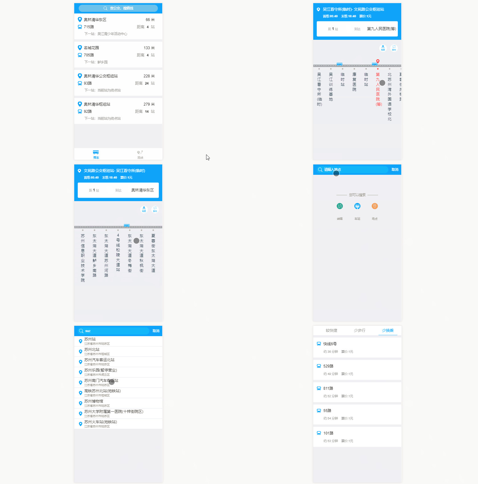
先給大家看下頁面效果:

如果有需要源碼的童鞋請移步我的github地址 vue搭建實時公交 (歡迎star)
實現思路
在vue項目中導入高德地圖 具體功能調用相應高德js APi
1.在vue項目中導入高德地圖
1.修改webpac.base.conf.js文件
externals: {
 'AMap': 'AMap'
 }
2.引入sdk 引入有兩種方式,一種是在index頁面直接引入
<script type="text/javascript" src="http://webapi.amap.com/maps?v=1.3&key=您申請的key值"></script>
還有一種是異步加載
<script src="http://webapi.amap.com/maps?v=1.3&key=您申請的key值&callback=init"></script>
<script>
 function init(){
  var map = new AMap.Map('container', {
   center: [117.000923, 36.675807],
   zoom: 6
  });
  map.plugin(["AMap.ToolBar"], function() {
   map.addControl(new AMap.ToolBar());
  });
 }
</script>
注意不管是采用哪種方式,都要保證你想要加載地圖的js文件,在引入的sdk之后。這樣,在第三步的時候,才不會報錯
3.在當前需要加載vue頁面引入
import AMap from 'AMap'
原文鏈接: https://www.jb51.net/article/112413.htm
2.附近站點功能
AMap.service(['AMap.PlaceSearch'], function () {
  var placeSearch = new AMap.PlaceSearch({ // 構造地點查詢類
  pageSize: 4,
  typ: '',
  pageIndex: 1,
  city: '蘇州' // 城市
  })
  // 中心點坐標
  // [currentLocation.lng,currentLocation.lat]
  // 120.6400961887,31.1411187922
  var currentLocation = true
  if (currentLocation !== undefined) {
  placeSearch.searchNearBy('公交站點', [120.6400961887, 31.1411187922], 1500, function (status, result) {
   if (status === 'complete' && result.info === 'OK') {
   var pois = result.poiList.pois
   var random = [4, 4, 24, 14]
   pois.forEach((item, index) => {
    this.items.push({
    site: item.name.substr(0, item.name.indexOf('(')),
    line: item.address,
    distance: item.distance,
    next_site: '',
    sitenum: random[index],
    siteId: item.id
    })
    this.lineInfo(item.address.substr(0, item.address.indexOf(';') - 1), item.id, index)
   })
   console.log(result.poiList)
   }
  }.bind(this))
  }
 }.bind(this))
這邊主要調用高德周邊搜索API,構造地點查詢類tye 設為空,采用公交站點為關鍵字進行查詢,這邊中心點坐標是寫死的,各位小伙伴可以調用高德定位api去獲得當前坐標
3.線路實時詳情
AMap.service(['AMap.LineSearch'], function () {
  var linesearch = new AMap.LineSearch({
  pageIndex: 1,
  city: this.city,
  pageSize: 20,
  extensions: 'all' // 返回全部信息
  })
  linesearch.search(this.lineName, function (status, result) {
  // 取回公交路線查詢結果
  if (status === 'complete' && result.info === 'OK') {
   this.lineInfo = result.lineInfo
   var tips = result.lineInfo[0]
   console.log(tips)
   this.from = tips.start_stop + '-'
   this.to = tips.end_stop
   this.lineId = tips.id
   if (tips.stime.length !== 0 && tips.length !== 0) {
   this.time_s = tips.stime.substr(0, 2) + ':' + tips.stime.substr(2, 2)
   this.time_e = tips.etime.substr(0, 2) + ':' + tips.etime.substr(2, 2)
   } else {
   this.time_s = '05:40'
   this.time_e = '18:40'
   }
   this.pay = tips.basic_price
   this.listWidth = tips.via_stops.length
   this.backImage.width = tips.via_stops.length + 'rem'
   tips.via_stops.forEach((item, index) => {
   if (item.id === this.siteId) {
    this.ind = index
    console.log(index)
    this.showActive(this.ind, this.siteName)
   }
   this.siteList.push({
    siteName: item.name,
    siteLat: item.location.lat,
    siteLng: item.location.lng
   })
   })
  } else {
   // 無數據或者查詢失敗
  }
  // setInterval(busposition(), 60000)
  }.bind(this))
 }.bind(this))
 },
這邊調用公交路線查詢接口,查詢相關路線詳情,這邊小車車的位置是一個寫死數組(實際情況可以根據班車GPS坐標判斷班車在哪兩個站點之間),可以點擊相應站點顯示最近班車相聚站點數
4.輸入提示
this.autocomplete.search(this.keywords, function (status, result) {
  if (status === 'complete' && result.info === 'OK') {
   var tips = result.tips
   this.hisTips = []
   console.log('tips', tips)
   for (var i = 0; i < tips.length; i++) {
   if (tips[i].location !== '' && undefined !== tips[i].location && tips[i].district.substr(0, 6) === '江蘇省蘇州市') {
    this.hisTips.push({
    lng: tips[i].location.lng,
    lat: tips[i].location.lat,
    name: tips[i].name,
    district: tips[i].district
    })
   }
   }
  } else {
  }
  }.bind(this))
這邊使用指令v-on:input調用我們輸入提示的方法進行列表展示
5.換乘詳情
AMap.service('AMap.Transfer', function () { // 回調函數
  // 實例化Transfer
  var transptions = {
  policy: 0, // 乘車策略,少時間0 少步行3 最少換乘2
  city: '蘇州' // 城市
  }
  this.transfer = new AMap.Transfer(transptions)
  this.Linesearch()
 }.bind(this))
this.transfer.search([this.$route.query.fromAddressLng, this.$route.query.fromAddressLat], [this.$route.query.toAddressLng, this.$route.query.toAddressLat], function (status, result) {
  console.log(status)
  console.log(result)
  if (status === 'complete' && result.info === 'OK') {
   var plans = result.plans
   console.log('plans', plans)
   for (var i = 0; i < plans.length; i++) {
   var cost = plans[i].cost
   var time = parseInt(plans[i].time / 60)
   var segments = plans[i].segments
   var trans = []
   if (segments !== '' && segments !== undefined) {
    for (var j = 0; j < segments.length; j++) {
    if (segments[j].transit_mode === 'BUS') {
     const linename = segments[j].instruction
     trans.push(linename.substr(2, linename.indexOf('(') - 2))
    } else if (segments[j].transit_mode === 'SUBWAY') {
     const linename = segments[j].instruction
     trans.push(linename.substr(2, linename.indexOf('線') - 2))
    }
    }
   }
   this.plan.push({
    cost: cost,
    time: time,
    trans: trans
   })
   }
  } else {
  }
}.bind(this))這里我們調用transfer.search()傳入起點和終點坐標,是通過輸入提示獲得的, 把得到結果進行列表展示
感謝你能夠認真閱讀完這篇文章,希望小編分享的“Vue使用高德地圖如何搭建實時公交應用功能”這篇文章對大家有幫助,同時也希望大家多多支持億速云,關注億速云行業資訊頻道,更多相關知識等著你來學習!
免責聲明:本站發布的內容(圖片、視頻和文字)以原創、轉載和分享為主,文章觀點不代表本網站立場,如果涉及侵權請聯系站長郵箱:is@yisu.com進行舉報,并提供相關證據,一經查實,將立刻刪除涉嫌侵權內容。